
A global team of remote sensing specialists and mangrove experts have developed the highest quality global mangrove map produced to date1. The maps are directly being applied to plan mangrove conservation and restoration field projects, and serve as a basis for a global ‘restoration potential’ map2. The maps are produced by ‘Mangrove Watch Africa’, as part of the ten year Mangrove Capital Africa programme by Wetlands International. Mangrove Capital Africa is led by Wetlands International and financed by DOB Ecology. The Mangrove Watch Africa work is mostly carried out by our partners Aberystwyth University and solo Earth Observation (soloEO). The data used was provided for free by JAXA, ESA and NASA.
Changes in mangrove cover over time
The first product that the team produced, is a global baseline mangrove extent map for the year 2010, based on satellite images. The baseline forms part of a timeseries that shows changes in mangrove cover on a global scale.
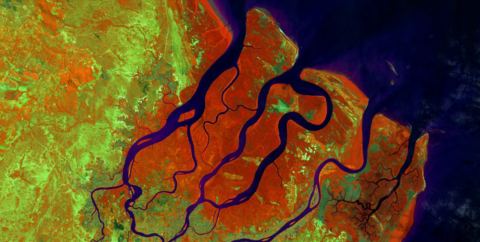
Cloudless mosaic of the Rufiji Delta in false colour infrared. Mangroves are dark-red, purple/black is water, and terrestrial ecosystems show up in green (based on ESA remote sensing imagery).
Weekly updates using radar data
Mangrove Watch Africa is currently developing a monitoring system using radar data obtained by the European Space Agency’s Sentinel 1 constellation. The system will ultimately be able to provide weekly updates of the maps, which can be used to track changes such as mangrove clearing caused by illegal logging or degradation caused by changes in hydrology and sedimentation. The big advantage of using radar data for this is that radar can ‘see through’ clouds.
State of mangroves
Lastly, the expert team produces maps on biomass, height, and other mangrove characteristics, which are used in the field to determine the state of the mangroves.
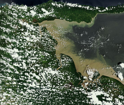
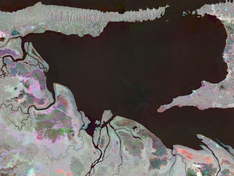
Optical (left) vs radar (right) image from the same area on the same date, note how clouds do not affect the radar image.
On the ground use
The maps are already used in two sites in Africa: The Rufiji Delta in Tanzania, and the Saloum Delta in Senegal. For example, in the Saloum Delta, the field team uses the mangrove cover change maps to identify where mangroves can best be restored. Local authorities, such as the Tanzania Forest Service, will soon also start using the mangrove extent and change maps for developing the forest management plan for the Rufiji Delta. They will furthermore use the monitoring maps to identify where illegal logging takes place, which was previously impossible due to limited resources. The Mangrove Capital Africa programme will be upscaled later in 2019, and we will ultimately work in ten countries in Africa to protect and restore mangroves. The Mangrove Watch Africa maps will be open access! They are currently in the process of peer-review and therefore not published yet.
Verifying the maps
The field team also obtains data and feeds them into the Mangrove Watch Africa team, resulting in even more accurate maps. Field staff are trained in gathering data using different methods, including drones and a newly developed App. Spatial data collected with drones is extremely precise, and complements the larger scale mangrove maps, serving as a tool for validation of the satellite images. Additionally, the images are extremely suitable for monitoring (for example restoration sites). Moreover, drone pictures and videos are valuable communications materials, showing the beauty of the mangrove ecosystem from a distance.
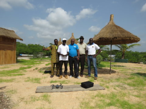
Some of the participants of mangrove data gathering training in July 2018 in Senegal.
More information
Learn more about Mangrove Capital Africa in the Rufiji delta, Tanzania; and in West Africa (in French).
- Bunting, P., A. Rosenqvist, R. M. Lucas, L.‐M. Rebelo, L. Hilarides, N. Thomas, et al. 2018. The global mangrove watch—a new 2010 global baseline of mangrove extent. Remote Sens. 10, 1669. https://doi.org/10.3390/rs10101669
- https://oceanwealth.org/mangrove-restoration/