
The objective of this project is to explore the potential of Earth observation (EO) satellite data for taking stock of, and monitoring, wetlands, a vital component of the global water resources ecosystem. The activity will pilot-design and develop of a user friendly digital system for use by the Ugandan Ministry of Water and Environment. The system will enable wetland practitioners and decision makers to generate spatial time series statistical data for inventorying and monitoring national wetland resources. This is a unique attempt to demonstrate the potential of satellite-derived EO data to provide a full national wetland inventory in Uganda and serving as a blueprint to other countries of East Africa.
The project is consistent with the upcoming monitoring requirements in the context of SDG indicator 6.6.1 “Change in the extent of water-related ecosystems over time”. It also recognizes the critical importance of supporting developing countries in strengthening the capacity of national statistical offices and data systems to ensure access to high quality, timely, reliable and disaggregated data.
The project is funded by the Global Partnership on Sustainable Development Data (GPSDD) with support from the World Bank’s Trust Fund for Statistical Capacity Building (TFSCB). The workflow for generating statistics for display in the portal is included in the GlobWetland-Africa Toolbox, developed as part of the GlobWetland-Africa (GWA) project funded by the European Space Agency. For access, please go to the GWA website and download the latest version of the toolbox (www.globwetland-africa.org).
Major Achievements
The final deliverables from the project include:
- Toolbox for wetland inventory mapping, based on the GlobWetland Toolbox, with extended functionality for reporting on SDG 6.6.1.
- Baseline wetland inventory map for Uganda based on Sentinel-1 and Sentinel-2 data for 2016 and 2017. Validation has been performed incorporating in situ data collected by the Ministry of Water and Environment and RAMCEA.
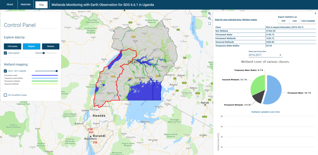
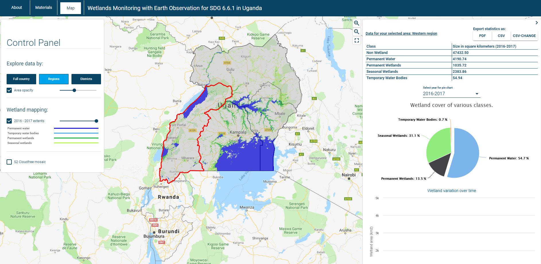
- Online portal for SDG reporting on SDG indicator 6.6.1 on Wetland extent (http://uganda-wetlands.dhigroup.com/)
- Training of national stakeholders in Uganda, as well as from the other RAMCEA countries
- A “lessons learned”-document and a “Roadmap”-document for roll-out of method, toolbox and online platform to the other RAMCEA countries.
A key part of this project has been to carry out capacity building in institutions related to wetland mapping and management both within Uganda and the other RAMCEA member states. Three trainings have been carried out, all with 15+ participants from a wide range of institutions. These include (not exhaustive list):
- Ministry of Water and Environment, Uganda
- National Forest Authority, Uganda
- Nile Basin Initiative, Uganda
- Uganda Bureau of Statistics, Uganda
- Kenya Wildlife Service, Kenya
- Rwanda Environment Management Authority, Rwanda
Challenges
Some of the challenges experienced during the execution of the project include:
- Technical capacity building is required in order to understand the capabilities of EO data for wetland mapping, including the limitations.
- To take the step from the information derived from the satellite data to a national wetland inventory, local knowledge is needed for applying the methodology and validating the results. These data need to be collected, following a common framework for identification of classes and reporting.
- Data volume is a challenge for national-scale inventories as significant amounts of data need to be processed. This is a challenge both in terms of internet access bandwidth, storage and processing capacity. Cloud platforms could help mitigate these issues.
Next Steps
The methodology has been demonstrated on the national level in Uganda, but challenges remain to ensure uptake in Uganda, and for roll-out to other countries in the region:
- Technical expertise has been developed, but this needs to be maintained and built upon. A user group has been established within the organizations that have participated in the trainings, to ensure a forum for knowledge sharing. As part of the last training, a small group of people has been identified which will be nominated to act as trainers.
- Funding is required for further capacity building both within Uganda, but especially for roll-out to the other RAMCEA countries.
- The online portal will be transferred to the Ministry of Water and Environment (supported by RAMCEA), to ensure local ownership of the reporting portal after project closure.
- Engage with the custodian agency (UNEP) for SDG indicator 6.6.1., to discuss how to improve the current methodology for data collection and reporting for the indicator based on the tools and lessons learned from this project. This will also be done as part of the ESA ‘EO for SDG’ project, involving some of the same partners from this project.
Lead Implementing Organization
Ramsar Centre for Eastern Africa (RAMCEA)
Supporting Organizations
- Ministry of Water and Environment, of the Republic of Uganda
- DHI GRAS, Denmark
- GeoVille, Austria
- ITC University of Twente, Netherlands
- European Space Agency, Italy
- Bureau of Statistics, Uganda
Point of Contact
Mr. Paul Mafabi (RAMCEA) or Mads Olander Rasmussen (mora[at]dhigroup.com)