
Introduction
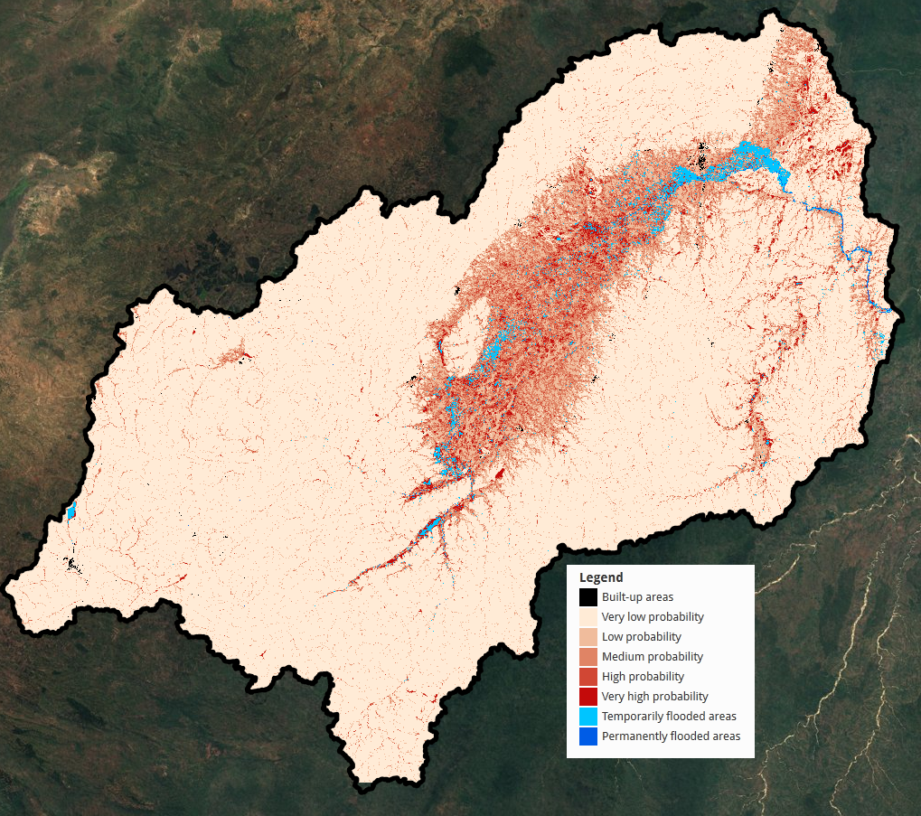
Kilombero is the largest seasonal wetland in East Africa. It is designated as Ramsar site and covers an area of 8.000 km², but the region providing ecosystem services (bushmeat, clean water, fish, fertile lands, habitat) is much larger. Its floodplain hosts peat swamps, alluvial grasslands, Miombo woodlands, evergreen forests and since recently, vast extensions of subsistence crops of rice and maize. A large part of the valley is flooded most years during the rainy season (March-May). The driest period lasts from July until October. The valley is inhabited by several endemic species and several large mammals such as elephant, buffalo, baboon, zebra, eland and the endangered puku antelope. It is estimated that 75% of the total puku population is living in the Kilombero Valley. Kilombero is not only a habitat for numerous species, but it also functions as corridor between two major wild life areas: the Selous Game reserve and the Udzungwa National Park. It was chosen as a test-site in the SWOS project and different methods were applied to assess the changes that took place in the area from the 1990’s to now. Figure 1 shows a map that shows the potential wetland areas in the Kilombero catchment on a scale from permanently and temporarily flooded areas and areas of high wetland probability to areas of low probability and built-up areas.
The Kilombero is part of the Southern Agricultural Growth Corridor of Tanzania (SAGCOT), a public and private initiative that aims to boost agricultural productivity, improve food security, and reduce poverty ensuring environmental sustainability through the commercialization of smallholder agriculture. Immigration and food production have increased during the last 20 years in the valley. In combination with weak management systems, this has caused a rampant land transformation from natural grasslands and open woodland into arable land. The result of this is that the vital wildlife corridors linking the Selous Game reserve and the Udzungwa National Park have lost their functionality, leaving populations of big mammals isolated. The increase in human population has also caused conflicts between agro-pastoralists and local farmers. Officials are aware of these problems, but a lack of spatial and temporal information has so far hindered the efficient application of solutions.
During the last 20 years several policies have been enforced to regulate land use with a focus on providing tenure security and developing irrigation agriculture in the valley. Besides, the EU is providing support for sustainable accelerated agricultural developments via the KILORWEMP (Kilombero and Lower Rufiji Wetlands Ecosystem Management Plan) co-funding. On the other hand, wetland management in Tanzania has been mainly regulated only by wildlife management policies while uncontrolled agriculture has been rapidly changing the landscape. There is thus a need of inter-sector coordination for wetland management; hydrological, wild management and agriculture development plans. Such inter-sector coordination will help locals and officials to understand the function of wetlands in multiple sectors such as fishing, grazing, agriculture and settlement, forestry and hunting.
Methods and Results
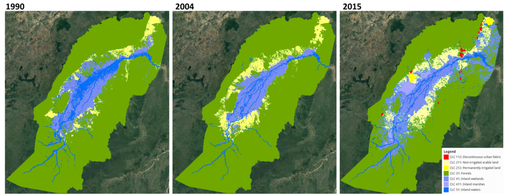
Using geomorphological criteria, the potential wetland areas of the floodplain were mapped. Using Sentinel-2, Landsat-5 and Rapid Eye data changes that have taken place in the floodplain since 1990 were analyzed. This clearly shows how agricultural expansion and deforestation have reduced the wetland and forested areas, especially in the period from 2004 to 2015. The reduction of these key natural habitats is the cause for the loss of functionality of several of the natural corridors that are important for the migration of different animal species.

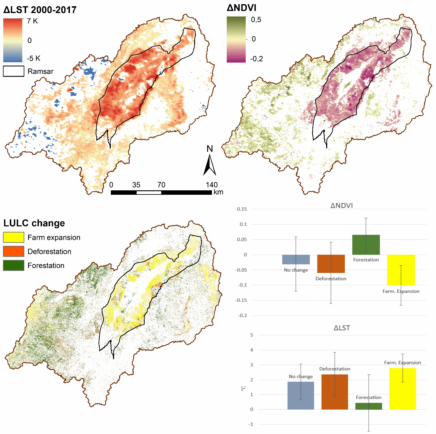
Consequences of land use change were analysed by calculating LST and normalized difference vegetation indices (NDVI) for the whole catchment. The results showed how farmland expansion and deforestation are increasing the LST of the valley and the wetland. This also means that LST is a suitable indicator for identifying processes of land-use change.
Conclusions and Outcomes
All products and conclusions were delivered to Tanzanian users. SWOS products have been used as information products for the Ramsar Advisory Mission Report on the status of Kilombero. In turn, these reports are being used by authorities to estimate the capacity of the ecosystem to switch from traditional (and less efficient) to more modern agricultural practices. SWOS products are being used as well for resolving property rights conflicts by identifying what areas are being cultivated and since when. Based on these products, certain areas identified as not-yet cultivated or not suitable for agriculture are being considered for protection regimes.
The outcomes of the collaboration between SWOS partners and users have been materialized in two peer-reviewed publications, Leemuis et al. 20171 and Muro et al. 20182
- Leemhuis, C., Thonfeld, F., Näschen, K., Steinbach, S., Muro, J., Strauch, A., López, A., Daconto, G., Games, I. & B. Diekkrüger (2017): Sustainability in the Food-Water-Ecosystem Nexus: The Role of Land Use and Land Cover Change for Water Resources and Ecosystems in the Kilombero Wetland, Tanzania. Sustainability 9, 1513.
- Muro, J., Strauch, A., Heinemann, A., Steinbach, S., Thonfeld, F., Waske, B. & B. Diekkrüger (2018): Land surface temperature trends as indicator of land use changes in wetlands. International Journal of Applied Earth Observation and Geoinformation, Volume 70, Pages 62-71.